


Information as of May-June 2011
VISA: You can get the visa on arrival in all major borders, however if you plan to cross from Ethiopia to Kenya through lake Turkana you need to have the visa in advance (we got the visa in the Kenyan embassy in Addis, 25USD for 90 days)
ONWARD VISA: In Nairobi you can get a visa for Tanzania and Uganda (you can also get them on arrival in all major borders). It is almost impossible to get a visa for Somalia and visas for Ethiopia are not anymore issued in Nairobi. We did not hear about other cyclists crossing from Kenya to South Sudan, however the situation might change with the separation of the country.
WEATHER: Try to avoid the rainy seasons between March to May and October to December
FOOD: Ugali (a staple made from maize flour) is some kind of polenta and the most basic food you can get that makes you full. Kenyans are also meat lovers, try nyama choma (barbecued meat, often goat or lamb). The food is very diverse: beans, lentils, rice (pulau), vegetables (sukuma wiki, spinach, cabagge, ...). You can also find many fruits: banana, avocado, mango. Supermarkets have a very wide selection of items (it feels almost like back at home in Europe). In Kenya you can drink tea (mostly with milk). For breakfast there is a good range of food (chapati, dougnuts, mandazi - fried bread,...)
WATER: In the Turkana area it is better to boil/filter the water though it will still remain a bit saulty. In big towns you can drink water from the tap.
SLEEPING: Guest houses in Kenya are good value for money. In Turkana and other remote areas the missions will host you.
CAMPING SPOTS: Nice camping spots around Mt. Kenya and Laikipa. Watch out for wild animals!
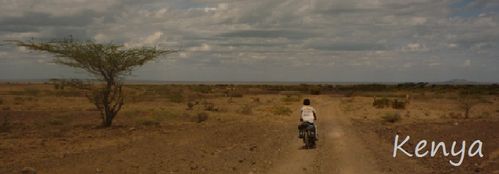
ROUTES: We crossed from Ethiopia to Kenya through the West side route of Lake Turkana (Omorate border). It is a very interesting way to cross due to the tribes you will see on both sides. Then we followed the main road from Kalakol through Lodwar, Lokichar, Kainuk, Kitale, Eldoret to Nakuru. Afterwards we went to Mt. Kenya using the road that goes through Nyahururu and the C-76, directly to Nanyuki. We did some off-road around Laikipia area (north of Nanyuki to Doldol, Ewaso, Kinamba and Kimanjo, where you can see wild animals, maasai and samburu tribes: we really enjoyed very much Laikipia, one of our highlights in Kenya). We finally crossed to Uganda at the Suam border, next to Kitale and Mt. Elgon.
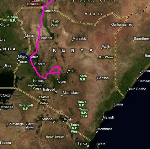
ROAD: The Lake Turkana route is a sandy piste from the border till Kalakol (see below for further details and roadmap). From Kalakol to Lodwar there is a good tarmac road. 25km after Lodwar the road deteriorates and changes to a very rough and corrugated piste till the village named Marich Pass, afterwards it is good tarmac. There are some security concerns about bandits in the stretch from Lokichar to Kainuk (ask about the situation before you bike there). The main road connecting Kitale to Nakuru is paved but full of tracks and lorries bringing goods from Mombasa port to Uganda, Rwanda, Burundi. Laikipia are is 100% piste but beautiful biking with no traffic and great sceanery and animals. The Mt Elgon border crossing to Uganda at Suam is not paved.
TOPOGRAPHY: The Rift valley is quite hilly. The surface is more flat in Turkana and Laikipia areas.
ORIENTATION: Easy to navigate in general, though you can get lost in Laikipia (savanah landscape style)
LOCALS: Most Kenyans are helpful, knowledgeable and well-informed people (it is very easy to have an interesting conversation with them about any topic). They also speak very good English.
ANIMALS: It is not allowed to bike in the National Parks. Some roads go through fenced reserves where you can spot animals. In Laikipia area it is very common to see elephants, jiraffes, zebras and other animals along the road (it is not an official national park and biking is allowed there)
ONWARD TRAVEL: Roads to Tanzania and Uganda are open for foreigners. At the time being it is not advisible to go by land to Somalia or South Sudan.
LAKE TURKANA ROUTE: details and more information
We highly recommend to take this route (so far it has been one of our highlights starting in Egypt) and despite what you can read in other webs/blogs or forums about its toughness we would like to demistify it and can confirm that:
- the tribes will never attack you even if they look dangerous with their AK-47 (they fight against each other, at the time we crossed the area there was a recent fight btw Dasenech and Turkana where more than 35 people were shot)
- you do not have to carry 15-20 lts of water (there is plenty of water sources on the way, see detailed route map below) just the water for the day
- it is not unbereably hot (it is a dessert but temperatures are below 50C)
- it is not possible to bike on the shore of the lake (the sand is too soft, take instead the main road that goes parallel some kms inland, easy to find and very difficult to get lost)
- it is not unbikeable at all (it is a sandy piste but you can bike most of the time, of course you will have to push in some parts but nothing too bad)
- It is not too remote (after Lowarengak you will pass simple huts and villages every 15kms and people walking on the way)
Some other considerations:
It is not yet an official border (since you do not get the entry stamp in the first Kenyan checkpost) but it is allowed for locals and foreigners to cross at this border point as long as you got the visa in advance (for both Ethiopia and Kenya direction)
The Ethiopian exit/entry visa stamp takes place in Omorate inmigration compound not at the border. The Kenyan stamp you have to get it in Nairobi not at the border. No visas are available at the border (get them in advance in the correspondant embassy)
To cross the Omo river use the local canoes instead of the association motorboat (the association will overcharge you for sure) Bear in mind that locals pay 5 Birr per person to cross in the canoe, the canoe driver makes max 25-30Birr each way he crosses the river. We used two canoes to cross both of us (in one) and the bikes and luggage (in the other)
It is advisible to get some Kenyan shillings in advance (best in Addis, also possible in Omorate but worse rate) since you do not find banks or money changers till Lodwar
Here is the ROUTE MAP with km:
Following kms (accumulated) start after crossing the Omo river in Omorate and going from Ethiopia to Kenya:
km 0: Omo river
km 24: Ethiopian last checkpost (they will just look at your passport, they do not stamp your visa but in Omorate)
Km 24- 36: No man´s land (very sandy)
km 36: Kenyan first checkpost (they will just look at your passport, they do not stamp your visa but in Nairobi)
km 47: Todenyang (first Kenyan village, there is a mission with water, no shops)
km 68: Lowarengak (village with very basic shops and restaurant, there is a mission)
km 92: Nariokotome mission (it is 3km off the main road)
km 102: Nachukui village (very basic shops and water)
km 111: Nariengewoy village (very basic shops and water)
km 122: Lomekui village(very basic shops and water)
km 138: Kataboy village (mission, very basic shops and water)
km 167: Kalakol village (many shops, mission, guesthouse) Tarmac starts!
UPDATE (February 2015) by Brigitte and Ivo - http://globoride.ch/
- There is a bridge now in Omorate to cross the Omo river (not officially opened but they could use it)
- Between Kalakol and Lodwar (and further direction Kitale) there is no more asphalt. Instead it is a gravel road with very few sections of asphalt.
- You can get the entry stamp to Kenya in Eldoret!! in the immigration departement office (N0° 31.393' E35° 16.581')
UGANDA - INFORMATION AS OF JUNE-JULY 2011
VISA: You can get the visa on arrival in all major borders (50 USD, 90 days)
ONWARD VISA: In Kampala you can get the visa for following countries: 1) Rwanda (also at the border if you apply first at www.migration.gov.rwa, payable at the border), 2) Burundi (also at the border), 3) Tanzania (also at the border), 4) DRC (also at the border), 5) Southern Sudan and 6) Sudan
WHEATER: Try to avoid the rainy seasons between March to June and October to November
FOOD: The food in Uganda is a combination of two sets: 1) Matoke (a staple made from banana plantain), casava, posho (same as ugali in Kenya), rice, cabagge, Irish potatoes (boiled potatoes) 2) beans, g-nuts, goat meat, beef meat (the second set determines the price of the food). You can also find very easily chips with salad. Milk tea, mandazi, chapati are very common for breakfast. Yoghourt and dairy products can be found in almost every place. You can also find many fruits (especially in the harvest season, June): pineapple, banana, papaya, avocado, mango, watermelon, jackfruit. Supermarkets have a very wide selection of items (it feels almost like back at home in Europe)
WATER: It is not advisable to drink water from the tap
SLEEPING: Guest houses in Uganda are good value for money
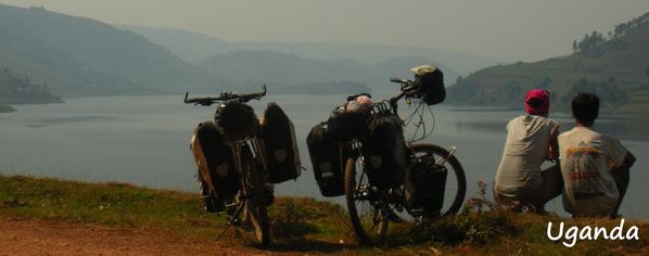
CAMPING SPOTS: It is almost impposible to camp in Uganda due to overpopulation. However you can still be lucky and find a nice spot in northern areas (around Mount Elgon and Karamojo) and Lake Bunyonyi
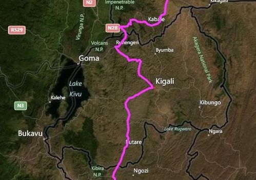
ROUTES:We crossed from Kenya to Uganda at the Suam border (next to Mt. Elgon). We followed the route to Kapchorwa (very scenic on a red piste), Sipi Falls, Mbale, Jinja (Source of the Nile, a bit dissapointing), Kampala, Fort Portal (scenic way along tea plantations and the background of Rwenzoris), Kasese, Queen Elizabeth NP (scenic along the main public road, you do not have to pay to cross it and you will see wild animals), Kabale, Lake Bunyonyi (very beautiful, follow the dirt road along the lake and not the tarmac main road) and Kisoro (nice ride). We finally crossed to Rwanda at Cyanika border

ROAD: The road between the Suam border post (next to Mt. Elgon) and Kapchorwa is a dirt road that can become very muddy if it rains. Afterwards the road is paved till Kampala, the major problem being the horrible traffic (especially btw Jinja and Kampala, where the road is very narrow). The public road crossing QE NPark is paved. The shortcut from Ishaka to Kagamba is a good piste (though very scenic along banana plantations). The road along Lake Bunyonyi is piste (should not be missed!). On the road to Kisoro there is a 20km stretch that is currently being paved. The road to Cyanika border is enterely paved
TOPOGRAPHY: The north of the country around Karamojo is plain, otherwise Uganda is a very hilly country, especially in the western and southern parts
ORIENTATION: Easy to navigate in general
LOCALS: Very firendly and helpful people. Easy to have good conversations, they also speak good English. In the south and in touristy places the kids can become a little bit annoying due to frequent shouts of "mzungu, give me money"
ANIMALS: It is allowed to bike in the QE National Park (you will see some wild animals)
ONWARD TRAVEL: Roads to DRC, Rwanda, Tanzania, Kenya and Southern Sudan are open for foreigners
RWANDA - INFORMATION AS OF JULY 2011
VISA: You can get the Rwandan visa at the border if you have applied before at www.migration.gov.rwa (just show the printed paper you will receive by email in 2-3 days and pay at the border). However it is advisible to apply for the Rwandan visa in an embassy before since you will get a cheaper and longer visa (eg. 1 month, 110,000 USh in Kampala).
ONWARD VISA: In Kigali you can get the visa for Burundi (also at the border), Tanzania (also at the border), DRC (also at the border), Uganda (also at the border)
WEATHER: Try to avoid the rainy season in Rwanda between March to May and October to November. The hottest months are August and September
FOOD:For breakfast it is easy to have chapati and tea together with mandazi. For lunch you will get excellent buffets in almost every village: the buffet is one plate (all you can eat) of rice, beans, matoke, potatoes, french fries, veg, spaghettis. Fruits are not that great as in Uganda but you will still be able to find good pineapples, avocado, bananas. There is a Nakumatt supermarket in Kigali with an excellent range of products.
WATER: It is not advisable to drink water from the tap, boil it first!
SLEEPING: Guest houses in Rwanda are good value for money
CAMPING SPOTS: It is almost impossible to camp in Rwanda due to overpopulation
ROUTES: We crossed from Uganda to Rwanda at Cyanika border. Then we continued through Ruhengeri (Parc National des Volcans) to Kigali. We took the main road along Nyanza and Butare to Burundi. We exited Rwanda at Kanyaru border. The piste along Lake Kivu is supposed to be nice and scenic
ROAD: The main road is excellent and entirely paved
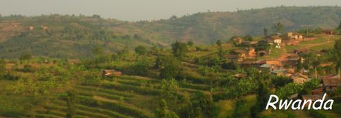
TOPOGRAPHY:All the country is hilly, especially in the northwest
ORIENTATION: Easy to navigate
LOCALS: Friendly people, especially in non touristy places. In more urban and developed places you will hear quiet often "give me money!". Mainly the elders can still speak Fench, with the younger generations you will be able to talk in English
ANIMALS: We did not see wild animals in Rwanda (we did not go to Akagera NP or tracking the mountain gorillas)
ONWARD TRAVEL: Roads to DRC, Rwanda, Tanzania and Burundi are open for foreigners

BURUNDI - INFORMATION AS OF JULY 20111
Visa: You can get a transit visa at all major borders (40USD for 3 days that can be extended once in Bujumbura for an additional amount of money/day). If you plan to stay longer than 3 days (Burundi is really worth it!) it is advisible to apply for the visa in an embassy before since you will get better conditions than extending your transit visa (eg. a visa for 1 month is 50USD in both Kampala and Kigali)
ONWARD VISAS: In Bujumbura you can get the visa for Rwanda (also at the border), Tanzania (also at the border) and DRC (also at the border)
WEATHER: Try to avoid the rainy season in Burundi from November to May
FOOD: For breakfast it is easy to have chapati, bread, tea and mandazi. Dairy products like milk and yoghurt are easy to find. For lunch you will get almost everywhere rice with beans, veg, matoke and ugali. Fish and meat are also frequent. Fruits are not that great as in Uganda but you will still be able to find good pineapples, avocado, bananas
WATER: Locals drink the water from the tap in the restaurants
SLEEPING: Guest houses in Burundi are excellent value for money
CAMPING SPOTS: It is difficult to camp due to overpopulation. However along Tanganyka lake you will be able to find great spots
ROUTES: We crossed from Rwanda to Burundi at Akanyaru border. We felt very safe all the way to Bujumbura and then along the Tanganyka lake to Tanzania. We exited Burundi at Mabanda-Manyovu border (open for foreigners!). From Rwanda to Tanzania it is almost 300kms in Burundi with a long 35kms downhill just before Buj and a steep uphill just after Nyanza Lac, before Mabanda- the last Burundian middle size village where you have to get the exit stamp, not at the border! The road is all the way very scenic both along the lake and in the mountains, excellent for riding a bicycle

ROAD: The main road from Rwanda through Buj, Tanganyka lake and Nyanza Lac to Mabanda is entirely paved. However it is a piste from Mabanda to Tanzania (approx. 22km)
TOPOGRAPHY: The mountain area is very hilly with some hard climbings but very scenic! Along Tanganyka lake it is almost flat and very enjoyable for riding
ORIENTATION: Easy to navigate
LOCALS: We found the locals to be extremely friendly, lets say LOVELY! ... and felt they were also truely happy to see foreigner visitors. In contrast to other countries of the region (eg Rwanda, Uganda) locals will very rarely ask for money, instead they will always greet you politely with a true smile and show big interest about your travel. The major communication language is French, some also speak a bit of English. Regarding contact to locals Burundi has been a great surprise for us (we felt really good among them and highly recommend this country despite all the warnings you might hear or read in the media)
ANIMALS:We did not see wild animals in Burundi (we did not go to PN de la Kibira)
ONWARD TRAVEL: Roads to DRC, Rwanda and Tanzania are open for foreigners
INFORMATION AS OF JULY 2011
VISA: You can get a transit visa for 14 days at all major borders (20 USD) or a 3 months visa (50 USD for most European countries)
ONWARD VISAS: You can get visas on the border for following countries (Burundi, Rwanda, Uganda, Kenya, Malawi, Mozambique and Zambia) so there is no need to apply in advance in embassies. Check the case of crossing to DRC by boat in case you need a visa in advance (better to apply in the Congolese consulate in Kigoma)
WEATHER: Try to avoid the rainy season from mid March to May and Nov-Dec. In the inland areas it rains from January to April. The global dry season is from June to August
FOOD: Normal breakfast in Tanzania is mandazi, dougnuts, chapati and tea (chai rangi- black tea or chai maziwa- milk tea). You can also find fresh milk and yogurt. Traditional dishes are ugali, fish, chicken, beef, goat, rice with beans, matoke, casava, rarely some vegetables (eg sukuma wiki) and french fries (chips). You can also find a chips omelette (chips mayai) that somehow resembles the traditional Spanish omelette. In terms of fruits you can find oranges, bananas, pineapples, papayas, apples and avocados
WATER: In general it is better to purify the water from the tap
SLEEPING: Guest houses are good value
CAMPING SPOTS: In the Western part of Tanzania you can find great places to pitch the tent
ROUTES: We crossed from Burundi to Tanzania at Mabanda-Manyovu border (open for foreigners!). We biked to Kigoma where we took the MV Liemba boat (every 2 weeks on Wednesday afternoon, tickets go on sale on Monday morning, our trip was on 20th July 2011) to cross Lake Tanganyika till Kasanga. From Kasanga we biked to Mpui (see description of shortcut below), Tunduma and Tukuyu (we used the shortcut from Mbalizi to Kiwira and we did not pass through Mbeya). Finally we crossed to Malawi at Songwe border.
SHORTCUT DESCRIPTION: if you are coming from Kasanga (MV Liemba) and heading to Mpui you do not need to go through Sumbawanga, here is a detailed route description with name of villages and kms from Kasanga to Mpui using the shortcut which is a good piste and a nice place to bike
Kasanga is km 0 (alt. 850mts), Kawala at km10 (alt. 1,100mts), Kasote at km15 (alt. 1,380mts), Limba at km35, Mkaowe at km42 (alt. 1,650mts), Mbuza at km52 (alt. 1,700mts), Matai at km63 (alt. 1,735mts).
At the junction out of Matai take right. 2km after take a left (this is km0, there is a sign to Itekresha). You reach Myunga (alt. 1,780mts) at km9, Kalalasi at km16, Itekresha at km26 (alt. 1,870mts), Kilesha at km32, Kambo at km38, then there is a junction at km40 (take left), Mwazye at km46 (alt. 1,860mts), Musoma at km51, Ilembo at km59, Mpui at km64
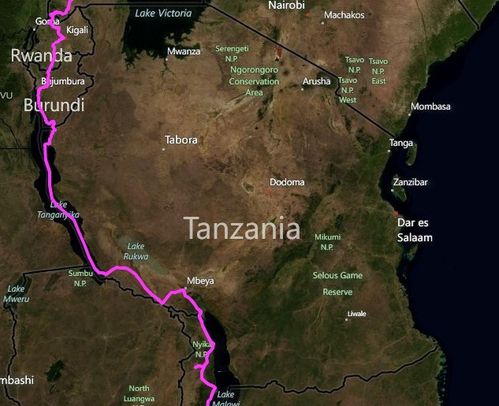
ROAD: The road from the Burundian border to Kigoma is all tarmac. From Kasanga to Sumbawanga and all the way to Tunduma they are building the tarmac road (expected to be completed in 2013). At the time of writing it is a rough corrugated piste from Mpui to Tunduma. From Tunduma to Tukuyu through Mbeya the road is asphalt, the shortcut between Mbalizi and Kiwira is a rough rocky piste (however it is a nice alternative to the busy tarmac road with both a continuous climb to 2,100mts and an easy downhill to Kiwira). The road to the Malawian border is tarmac
TOPOGRAPHY: The west part of Tanzania is quiet hilly but the climbs are continuous and not steep
ORIENTATION: Easy to navigate
LOCALS: We found Tanzanians to be very polite people. They do not get so excited when they see mzungus as in other African countries and they are always very respectful with their comments. We hardly heard the common African expresion of "mzungu, give me money". Easy to communicate in English although it is worth to learn some Swahili in the little villages
ANIMALS: We did not see wild animals in Western Tanzania (we did not go to Katavi NP)
ONWARD TRAVEL: Roads to Burundi, Rwanda, Uganda, Kenya, Zambia, Malawi and Mozambique are open for foreigners. Check the case of crossing by boat to DRC from Kigoma

Information as of August 2011
VISA: You can get a 30 days visa for free at the border for most Euorpean nationalities. However Swiss citizens have to apply in an embassy and get the visa in advance (in the practice it was possible to enter Malawi without the visa in advance for Corinne, Swiss, by getting a paper at the border (Songwe brigde) and reach the inmigration office in the nearest biggest town, Mzuzu, within the next 7 days, where you have to pay the visa fee, 70USD for 30 days). If you are Swiss we strongly recommend to have the visa in advance, you will save an entire morning of queing to get the visa in the inmigration office.
ONWARD VISAS: You can get visas on the border for following countries (Zambia, Mozambique, Tanzania) so there is no need to apply in advance in embassies. Check the case of crossing to Mozambique by boat at Cobue border, it should be possible to get the visa on arrival but things can change since it is not a major border)
WEATHER: Try to avoid the rainy season from November to March. Cool and dry (May to August), hot and dry ( September to November)
FOOD: For breakfast you can easily get boiled egg, mandazi, bread, samosa and tea. For lunch and dinner the common food is sima (same as ugali or posho) or rice with beef or beans. The bakeries are specially good in Malawi with good bread and little snacks like obama and bin laden buns. Fruits are not that great in Malawi, in August we only found bananas and very few avocados. French fries, maize corn, casava and fried bananas are easy to get in the street stalls. The supermarkets of Metro and People´s are almost in every big town and they have a good selection of products
WATER: You can drink the water from the tap!
SLEEPING: Nice campsites along the lake usually run by Westerners
CAMPING SPOTS: In the north of Malawi (in the mountains or along the lake) you can find some places to pitch the tent, central Malawi is very populated
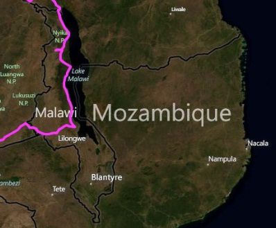
ROUTES: We entered Malawi from Tanzania at the Songwe border. We followed the road M1 till Mzuzu and then took the M5 till Salima. We headed afterwards to Lilongwe on the M14 and exited the country on the M12 to Zambia (Chipata border). From Chitimba we climbed up to Livingstonia and continued on the piste till Rumphi (we highly recommend it instead of taking the main road). From Rumphi we went to the Vwaza Reserve where we saw lots of hippos and elephants just camping next to Kazuni lake (no need to enter the reserve). From Mzuzu we recommend to take the M5 along the lake instead of the more direct M1 since it is more scenic
ROAD: The roads in Malawi are very good tarmac with amazingly very little traffic in the north of Malawi (M5 road along the lake). The piste from Chitimba to Livingstonia is tough the first 10-15km, afterwards it is much better till Rumphi.
TOPOGRAPHY: The north of Malawi is hilly, be ready for continous up and down biking (especially near Livingstonia and Nyika NP). Along the lake it is more flat and the hills appear again when you approach Lilongwe
ORIENTATION: Easy to navigate
LOCALS: Malawians are nice people, very correct and educated. However the kids are always asking for money, it is a constant shout of "give me.....water, food, money!" along the road. It can get really annoying, however it is by far not as bad as in Ethiopia where they throw you stones. Very easy to communicate in English.
ANIMALS: We saw lots of hippos and elephants in Vwaza Reserve (north Malawi)
ONWARD TRAVEL: Roads to Zambia, Tanzania and Mozambique are open for foreigners


